Monday, September 25, 2023

Half Dome Hike, Yosemite

 My friend Aeneas and I just hiked to the top of Half Dome. The National Park Service has a pretty good page about the route and the experience, if you want to see what the officials say.


The photo above is from a site called EarthTrekkers, they have a very good writeup about hiking the route. You start in Yosemite Valley (off the bottom of the photo), and climb up the back of Half Dome (upper left).    On the way out, we climbed a section of the John Muir Trail (green dashes) to the top of the upper waterfall, Nevada Falls,  then took the yellow route from there. On the way back we took the Mist Trail next to the waterfalls, which was very hard on my knees. Knee-wise, it would have been better to take the Mist Trail up and the Muir Trail down, but we couldn't take the Mist Trail up because it was closed from 7am to 3pm for trail maintenance. What with taking the section of John Muir Trail, and having to walk for a mile or so back to the car after we got back to the trailhead (because we didn't want to wait for the next bus), our day came in at right around 20 miles.  But the mileage isn't the main thing that makes this a fairly strenuous hike: instead, the issue is the elevation gain and to some extent the altitude.  The top of Half Dome is 4800 feet above the valley floor, but there are a few ups and downs along the way so by the time you get there you've climbed about 5100 feet.

Both Aeneas and I had been doing some hiking in the hills for a few weeks prior to our Half Dome excursion, so we didn't really have a problem with the hiking...although we were not speed demons, either.  We started our hike at about 7:30 a.m. and got to the top around 1 pm, with about a half hour of stops along the way to eat, drink, take photos, etc.  So that's about 2 mph average speed on the way up.  We started back down at about 2:30pm and took about 4 hours to get down, arriving just as the valley floor had fallen into shadow while Half Dome was still illuminated by the sun. 


I took about 8 pounds of liquids (100 ounces of water in a Camelback, and two 16-ounce bottles of juice) and was glad I did: I ended up drinking most of it, although I had enough left that I gave about 10 ounces to a couple of hikers who had run out while they were still about two hours from the end of the hike.  I recommend taking at least three liters of liquids for ordinary conditions, and well over 4 liters if the weather is hot or if you're not in very good shape. If you carry a few extra pounds of water, that's not going to make your day miserable (and you can always dump some if you find you really do have extra, although you should not do this until you are at least part way back).  But if you are short a few pounds of water that your body needs, that can make for a miserable or even dangerous experience.  I also took a fairly hefty amount of food: nuts, M&Ms, a couple of granola bars, fig bars, a Snickers bar, an apple, plus the 32 ounces of juice that I mentioned...probably about 2500 Calories.  That's still far short of what I used on the hike, which was probably over 4000 Calories, but it was plenty to keep me from 'bonking' and although I was a bit hungry when we got back at the end of the day I was never in any distress. Aeneas ate much less than me --- I think just 4 Clif Bars and a few of my fig bars -- and by the time we got back down he was obsessing about food.  I guess the point of this whole paragraph is: you are going to be doing  5200 feet of climbing and walking 15-20 miles depending on which route you take, and your body needs a lot of water and food to do an effort like that.  This is not the time to try to lose weight, this is the time to give your body what it needs so you can have a good time.


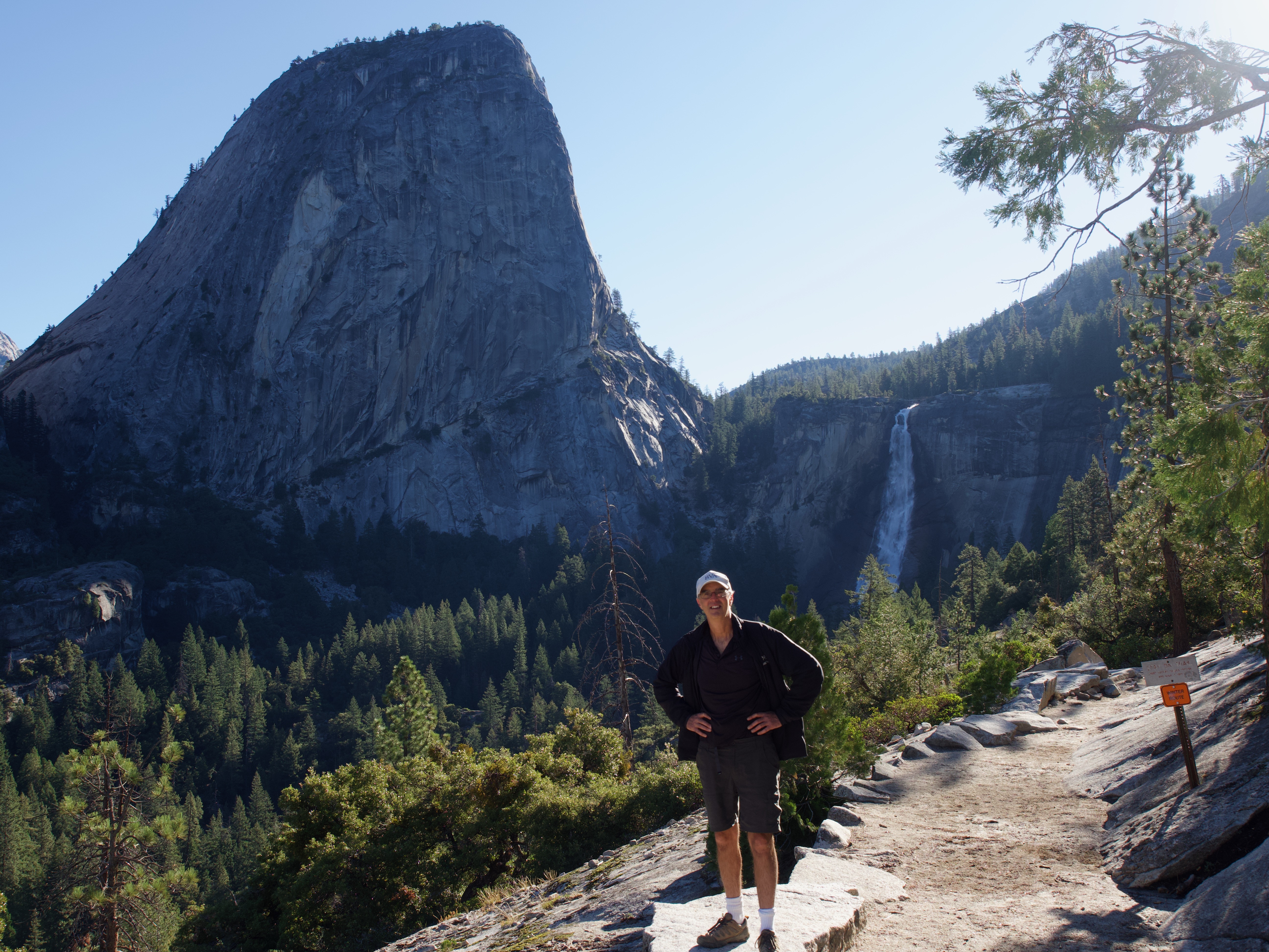
As you can see in the first photo in this post, you start by climbing past a couple of waterfalls.  Here's Aeneas with the upper falls (Nevada Falls) in the background. That's not Half Dome over his shoulder, it's a much smaller peak, the one that the route disappears behind in that route photo at the top.  As you can see, for this portion -- and all the way up until fairly near the back of Half Dome itself -- we were hiking through dry woodland, mostly whitebark pine and sequoias.


Above, check out these sequoias that have managed to grow in a thin crack in the granite.  This is at the top of Nevada Falls.

We didn't see much wildlife, which wasn't really a surprise. The wildlife we did see was very habituated to humans, which also shouldn't be a surprise since there is rarely a 5-minute period in which nobody passes on the trail.  Crows, jays, deer, and this Pileated Woodpecker were untroubled by our presence, having presumably seen several hundred people per day almost every day of their lives.


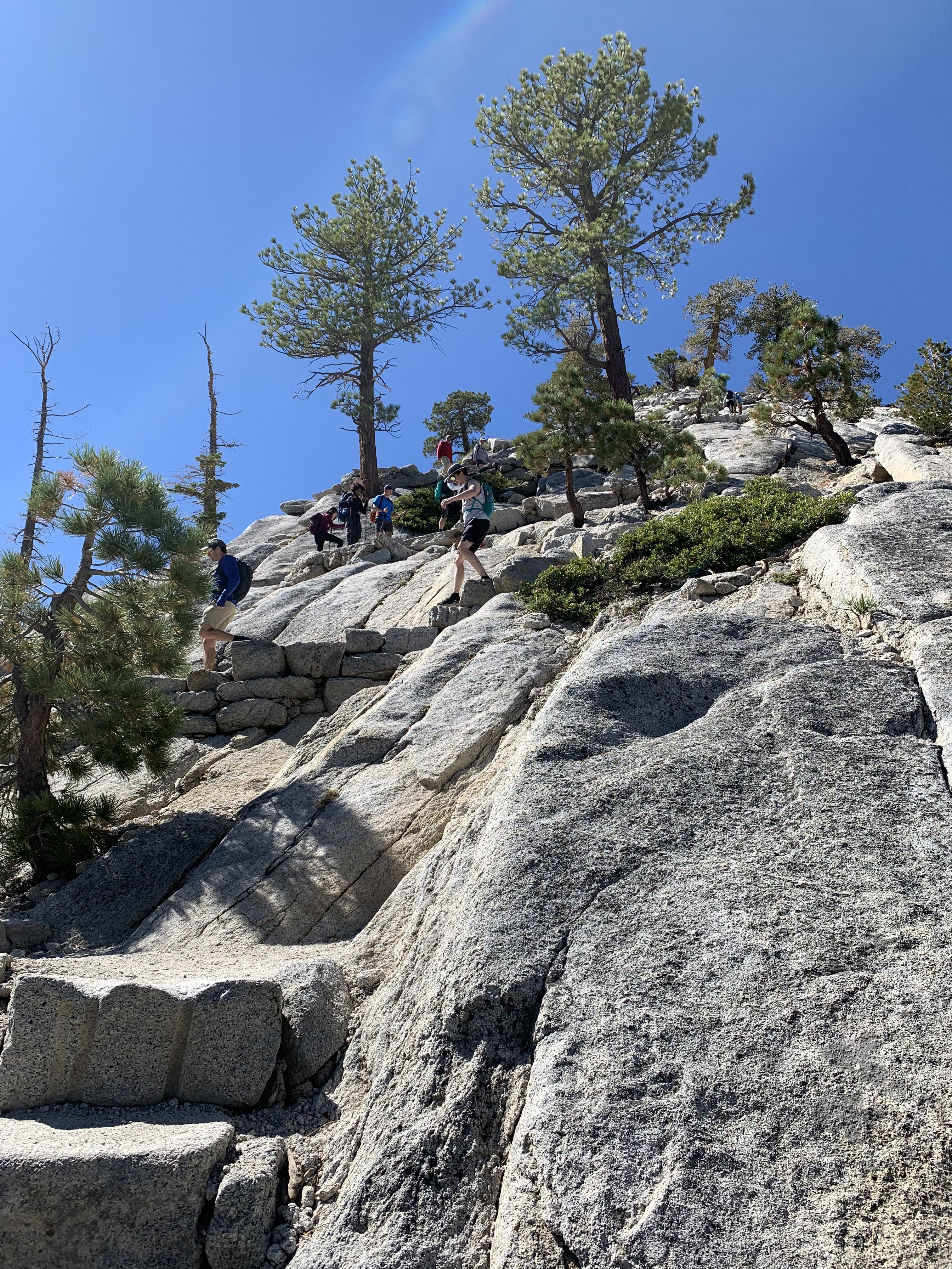
After several hours of hiking we got to the "sub-dome", a mound of granite that forms the approach to Half Dome's backside. The trail switchbacks up via granite steps that are a monumental achievement for Yosemite's trail-builders.  Many of the individual rocks weigh hundreds of pounds, and thousands of rocks were placed to make the trail. At this point there are only about 700 vertical feet left to climb, and you're over 8000 feet above sea level. I did notice the thin air, and my pulse was over 140 even though we were taking it quite easy. At this point we had already hiked 10 miles and done 5000 feet of climbing.


The final stretch is up "the cables", an almost comically dangerous segment where you pull yourself up steel cables that are anchored in the rock. 

The photo above is from the top of the sub-dome, looking at the back of Half Dome. If you click to see the full-size photo you can see the cables, including a sort of traffic jam at the top. 


Fatalities here are rare -- I think the most recent one was in 2019 -- but injuries are common, according to the ranger who checked our permit before letting us start up the sub-dome. (You must have a permit. You can get one through lottery, far in advance, if you're lucky; or, like us, you can keep submitting your name in a smaller, daily lottery, and if you are accepted then you climb two days later. We got our approval Wednesday night, drove up Thursday and stayed overnight in the valley, and hiked on Friday). 

Here are some people climbing the cables. The lowest person in the photo is just about to pass a big smear of blood; I don't know the story there, but I would guess someone fell on his nose or face and slid down a body length or so before managing to stop.  

The cables ought to be not a big deal, and we would have been up them in 15 minutes (for about 400 feet of vertical gain) except for other people.  There are people coming down who have to squeeze past, and, more problematic, we were stuck in a sort of traffic jam so we had to keep starting and stopping.  In a lot of places it's no big deal to stop and wait for a bit, you can find a place to put your feet (for instance, in the photo above you can see some of the horizontal boards that are placed at intervals), but other places you are standing on an steep face of smooth granite and you have to use your calf muscles and other muscles to stay there, so the stopping made it quite uncomfortable.  When we got near the top we discovered that our traffic jam was caused by some twenty-something guy who was freaking out and had to keep pausing for 30 seconds or so to psyche himself up for the next short segment.  My suggestion/request is: if you want to prove something to yourself or to others, as far as your ability to conquer your fear of heights, choose someplace where you won't inconvenience other people so much.  There are dozens of other cliffs and prominences in Yosemite where you can put yourself in a situation that is just as vertiginous, or even more so, without making other people wait in an awkward, uncomfortable, and somewhat dangerous situation.  


To the extent that the cables are actually dangerous, it's mostly because of...well, because of people.  Some of the people coming down were rushing and not staying in control; if one of them were to have stumbled and fallen or slid onto me, they might easily have knocked me off the cable I was holding onto. That probably wouldn't have been fatal, although it's not impossible, and it could easily have caused major injuries.  Most people were behaving fine, but not everyone. 

Fortunately there were no mishaps while we were on the cables. Eventually we got to the top -- after something like 30 minutes on the cables, when it should have been 15 -- and were rewarded by some truly spectacular views.  The valley floor is almost 5000 feet below. 


We hung out at the top for almost an hour, taking photos and looking around and eating and drinking, and then headed back, mostly retracing our route except that by the time we got to the Mist Trail the maintenance crew was done for the day so we were able to take the trail next to the waterfalls. Vernal Falls is in the photo below. 


All in all the day was a great reminder of what makes Yosemite so spectacular...and also a great reminder of why I haven't been there in fifteen years.  The hike is fairly tough, but hundreds of people do it every day. In no way is it a wilderness experience. You do get to see some fantastic natural sites but if you prefer  to experience natural beauty without a lot of other people around, as I do, then this is not the way to do it. I definitely don't regret doing it, but I probably won't do it again.


Thursday, June 22, 2023

Random stuff from Spain


This post is a catch-all for stuff we thought you might find interesting, but that didn't fit anywhere else. 

In an earlier post, we showed the breadmobile that makes the rounds of little towns in the Somiedo area. I assume that happens elsewhere too, but don't really know.

Earlier in the trip we had encountered a mini grocery store: this truck pulled up and a bunch of women gathered to do their daily shopping. One of them had done a special order of something, but the rest were just buying from the minimal selection of stuff on the shelves. As you can see, there were some fresh fruits and vegetables...makes sense: probably most of the customers do most of their food shopping by going infrequently to a supermarket in a larger town, but want fresh fruits and veggies.


Phil, in particular, tends to notice signage and to find some of it amusing.

Love this security sign. 

When we got to this spot we weren't 100% sure which way to go. Fortunately they had this helpful signpost. 


We've already noted the cat-on-a-keyboard nature of the Basque words and signs. Here's another nice example (click so you can see a bigger version). 


Another nice sign.


And another.  We did see bears, at Somiedo Natural Park (a mama with two cubs, and another mama with one) but only at a great distance.


Vermut (vermouth) is big in Spain. Indeed, you can say "I'll see you at vermut" to mean "I'll see you at noon." There's quite a wide range of flavors.


This beer was pretty good, malty and flavorful. But it bears nearly no resemblance to an IPA (India Pale Ale), which the bottle says it is supposed to be.  

That's a lot of chocolates!


Saturday, June 17, 2023

Vitoria-Gasteiz

Several years ago, our friend Cyrus was in the town of Vitoria-Gasteiz, in the Basque area of Spain. (Cyrus is a massage therapist, now with the St Louis Cardinals, and he was in Spain with the US Wrestling Team). Cyrus loved the town and told us we would love it too: According to Wikipedia, "it is the first Spanish municipality to be awarded the title of European Green Capital (in 2012) and it has been also recognized by the UN with the Global Green City Award (in 2019)."  On Cyrus's recommendation, we decided to give it a go.  We spent two days there and we loved it. 


It looks kinda empty here, but in fact the trams are heavily used, as are the bike paths. 


The first day, we walked a few miles from our hotel to the Samburua Wetlands, on the edge of the city.


The wetlands have lots of birds, and other animals including deer.


Juliet got this great picture of some storks. 


There are interesting murals on some of the walls in the city:


Our second (final) day, we rented bikes from the hotel and went for a ride around part of the perimeter of the city. There's are a few routes that go all the way around, but we just went partway and made several detours.

To get to the edge of the city, we followed one of the nice bike paths.

We biked through an arboretum...


...and through agricultural land.


We stopped for lunch at a cafe where a bike path crosses a country road. That's the bike path in the foreground.


All in all it was a great place to spend a couple of days. It would have been nice to have some more time. They have a museum of playing cards! Within the city there are several other interesting attractions too. Getting out into nature was our top priority but if we go back someday we might spend at least a bit of time in the city itself. We did at least walk around the old medieval center.

We are glad Cyrus recommended the city to us. Now we will recommend it too!


Monday, June 12, 2023

Drifting down the Sella River

Besides hiking and biking, we also spent a very pleasant few hours drifting down the Sella River in kayaks, surrounded at times by dozens of rambunctious Spaniards enjoying varying levels of intoxication. 

We started just above the town of Arriondas. There's a kind of exciting flume leading down to the river, so they give you a push and down you go.  Phil capsized right away at the bottom, so then the guys at the kayak place told everyone else "back-paddle on the left as soon as you hit the water."  Hey guys, maybe mention that a little earlier, eh?


Preparing to Launch.


The launch ramp.

The river is broad and shallow, with occasional minor rapids. The great thing is, there's a forested green band all the way down the river.  Every now and then the preserved area is quite narrow and you can see that you are just fifty yards from farm fields or a few houses, but mostly it is wide enough that you're basically out there in nature...with a bunch of other people drinking and carousing, of course. And this was well before the tourist season really gets started! I can only imagine what it's like on a hot day in July or August, when everyone decides getting out on the river would be a fun way to cool off.

Somehow Juliet managed to get a photo of Brigitte and Hal that didn't have other kayakers in it:

Brigitte and Hal

All in all it was a really fun outing, and gave Phil and Hal a much-needed rest day from their biking.


Sunday, June 11, 2023

Hiking in the Natural Parks of Asturias

 Walking? Hiking? When does a walk become a hike, or vice versa? I dunno. I suppose that for me, if I change into hiking boots or think about changing into hiking boots in order to go for a walk, it's a hike. Anyway we did both walking and hiking in Spain, everything from easy strolls along to steep trails in the mountains. In a month many of these routes will be busy or at least not empty, but in May and early June we pretty much had them to ourselves. 


In Somiedo Natural Park

Also Somiedo. That's Juliet off in the distance.


In the hills above the heavily touristed but pretty town of Potes.

Somiedo Natural Park. Really cool geology. Also, if you click to see the bigger photo you can see several traditional-style thatch-roof huts. 


Here's a close-up of some of the huts. Now used just for sheltering animals.

Of course there were also lovely rivers, creeks, bridges, etc.

Brigitte and Juliet did a walk along the coast. Loved it. 

It's a great area and a great time of year for birdwatching: lots of birds migrate up from Africa to breed, so the forests and fields are constantly loud with birdsong from both resident birds and migrants.


Here's a wagtail wagging its tail at us. 

We didn't get photos of the mama bear with cubs that we saw at Somiedo Natural Park -- they were much too far away -- nor the 'rebecos' (French word is chamois; they are antelope-like animals that live at high elevation).  The only time we saw a lot of people in one place at Somiedo was when we came upon a big group looking for bears. It turns out this was a meeting of nature guides from all of the parks in the region: at the end of the day, after the meeting was over, they all came out to see what they could see.


Anyway we got no photos of the charismatic megafauna. But here's a nice green lizard.


Even the tiniest towns have their own church.  Many of them are not used much (I'm sure some aren't used at all), and I would guess that eventually a lot of them will be torn down or converted to other uses or something. But for now they add a focal point to every little village.


This was definitely the right time for wildflowers, which were all over the meadows and along the roadsides in great profusion.

Spring wildflowers were everywhere.


Where there are flowers there are pollinators. We saw many bumblebees of different sizes and color patterns, and many butterflies.